Hong Kong News

Hong Kong to issue No 3 typhoon warning between noon and 2pm
The Hong Kong Observatory said it would issue the No 8 typhoon warning signal between 6pm and 9pm on Wednesday, with Severe Tropical Storm Ma-on expected to be closest to the city by Thursday morning.
With the No 3 signal expected between noon and 2pm, the government also announced that classes at kindergartens as well as schools for children with physical and intellectual disabilities would be suspended, but such places should remain open for contingency measures to look after students who had arrived.
“The Observatory will consider issuing the No 8 gale or storm signal between 6pm and 9pm. There will be rough to high seas and swells tonight. Members of the public are advised to stay away from the shoreline and not to engage in water sports,” the forecaster said in a statement at 9.45 am.
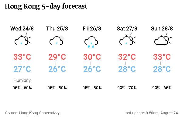
Hot weather is expected to persist on Wednesday morning, with a maximum temperature of about 33 degrees Celsius, followed by squally showers and thunderstorms later. Local winds will also strengthen at night.
“Ma-on is expected to be closest to Hong Kong on Thursday morning and may skirt within about 200km of the territory … The landfall intensity of Ma-on remains uncertain,” the Observatory said, adding the weather would improve towards the end of the week despite a few showers on Friday.

At noon, Ma-on, or saddle in Cantonese, was estimated to be about 440km southeast of Hong Kong and forecast to move west-northwest at about 25km/h in the general direction of the coast of western Guangdong.
Because of the coming storm, the Chai Wan Public Fill Barging Point was closed at 8.30am until further notice. The pilotage service in the port would also be suspended from noon, the Marine Department said.
Authorities warned that low-lying areas might also be flooded or experience backflow of seawater.
The No 1 typhoon signal has been in force since Tuesday night, with Ma-on edging closer to the vicinity of the Pearl River Delta “quickly”, according to the Observatory. The “very hot weather” warning is also in force.


